A leveled crater near Perach in the Chiemgau impact strewn field

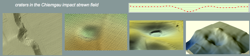
The air photo (1)* originates from the northern part of the impact strewn field near Perach and shows (arrow) a crater leveled on an acre.

  Image 1: Chiemgau impact; leveled crater near Perach
Source BLfD

  Image 2

By image processing, the in the original photo only adumbrated structure gains amazingly sharp contours (2) clearly exhibiting four different concentric zones (3):

  • a 5 m-diameter central area (black)
  • a 12 m-diameter adjoining zone (red)
  • an annular Zone not quite 10 m wide and with an outer diameter of c. 30 m (yellow)
  • an exterior zone (60 – 70 m diameter) displaying extensions radiating up to 50 m from the center.

  Image 3

The following attribution of the individual zones is suggested:

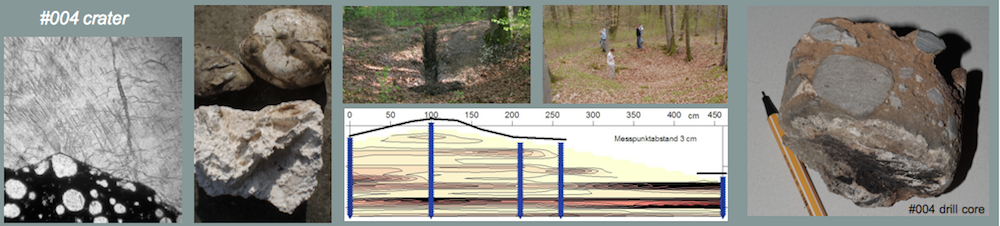
The interpretation of the central spot orients by the GPR (ground penetrating radar) measurements (Dr. Patzelt, Terrana Geophysik; inhttp://www.rssd.esa.int/SYS/docs/ll_transfers/295499_Roesler_pres.pdf  and http://www.rssd.esa.int/SYS/docs/ll_transfers/295499_roesler.pdf) that have been conducted over another crater (our crater no. 004 – also see http://www.chiemgau-impakt.de/mineral.html) located in the northern part of the strewn field. The GPR soundings show prominent reflections from the crater floor possibly related with strong compaction of the underground material. Assumed this compaction also exists within the Perach crater serving as impermeable rock, a corresponding moisture penetration could optically be traceable to the surface.

The adjoining 12 m-diameter zone could represent the material from the leveling of the crater. The annular zone is suggested to reflect remnants of the original rim wall. Taken the middle of this zone to have been the location of the rim crest, a 20 m diameter of the original crater results.

Finally, the exterior zone is suggested to reflect the zone of the crater ejecta radiating up to 50 m from the crater center.

This documentation of a ring structure illustrates that alternate explanations (geologic glacial formations, anthropogenic (archeological) structures, primitive industrial sites) readily and frequently given by opponents of the Chiemgau impact and skeptics of the meteorite origin for the innumerable craters, continue to have a hard time.

In any case, it is planned to investigate the Perach leveled crater by various geophysical measuring systems trying to characterize the optical zoning in more detail physically.


* In earlier texts, the air photo was erroneously labeled an infrared image.

On the Lake Tüttensee discussion:

Critics of the impact origin for the Lake Tüttensee crater (e.g., Doppler & Geiß 2005) argue that the strong deformations exhibited by the cobbles and boulders from the rim wall are the result of tectonic processes in the Alps and that the tectonically deformed clasts were transported and deposited in the region of the strewnfield. The impact advocates counter that such deformed cobbles and boulders would not have survived any transport over a distance of more than 50 m. Instead, they point to the typical features of a high-pressure/short-term process of deformation and to the fact that gravel pits outside the Lake Tüttensee area are void of these characteristically deformed rocks.

We have received a comment on this controversy by F. Claudin, geologist from Barcelona (Spain):

“We can compare the deformations observed in the Lake Tüttensee rim wall with the supposed deformations that must be present in other glacial moraines. In the Pyrenees, near Les Bordes de Llestui at the Clot and Malmarrui torrents, we can observe a glaciolacustrine-glacial complex. Neither in the clasts of the subglacial till nor in those of the supraglacial till, deformations as described for Lake Tüttensee can be seen. Only striae on the clasts are observed. The same observations can be made in the moraine deposits near Vilaller (Verge de Riupedrós, Sant Mamés, Sant Antoni), near the hospital of Vielha, or in the “Barranco de la runada” (near Senet). Glaciers may produce enough pressure to ensure striae deformations or fragmentation of clasts, but they are unable to produce short-term deformations under high confining pressure as seen in the photos of the Lake Tüttensee clasts. Typical aspects of the Pyrenees glacial deposits are shown down below the text.

The above-mentioned deposits have in more detail been described by

  • Bordonau, J (2000): Itinerario 3 (Vilaller, Hospital de Vielha, Valle de Llauset y Noguera Ribargozana), in Geopirineos, Monografias de Enseñanza de las Ciencias de la Tierra, Serie Itinerarios, nº 2.
  • Bordonau, J.; Pous, J., Queralt, P., Vilaplana, J.M. (1989) : Geometria y depósitos de las cubetas glaciolacustres del Pirineo. Estudios Geológicos, 45, 1-2: 71-79.
  • Bordonau, J., Vilaplana, J.M., Fontugne, M. (1993) : The glaciolacustrine complex of Llestui (Central South Pyrenees) : a key-locality for the chronology of the last glacial cycle in the Pyrenees. C.R. Acad. Sci. Paris, 316, série II: 807-813.
  • Vilaplana, J.M., Bordonau, J. (1989): Dynamique sédimentaire lacustre de marge glaciaire : le paléolac de Llestui (Noguera Ribagorçana, Versant Sud des Pyrénées), Bull. A.F.E.Q., 1989-4 : 219-224.”


Ein außergewöhnliches prähistorisches Artefakt aus den Auswurfmassen des Meteoritenkraters Tüttensee (Chiemgau )

PDF Download

Ein außergewöhnliches prähistorisches Artefakt aus den Auswurfmassen des Meteoritenkraters Tüttensee (Chiemgau )

von Till Ernstson, 2007