Article on the Thunderhole phenomenon in the Chiemgau impact area:
http://www.springerlink.com/content/1166143hjp83647w/ (Reference and abstract)
Kord Ernstson, Werner Mayer, Andreas Neumair and Dirk Sudhaus
CENTRAL EUROPEAN JOURNAL OF GEOSCIENCES

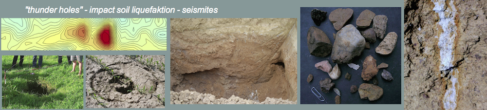
The article describes the very first geologic and geophysical investigations of the so-called Thunderhole (“Donnerloch“) phenomenon in the region of the small town of Kienberg north of Lake Chiemsee in Southeast Bavaria. The authors conclude that the innumerable enigmatic sudden sinkhole cave-ins having happened in living memory originate from late and even today acting processes of an earlier shock-induced underground rock liquefaction known from strong earthquake shocks. The geologically prominent underground structures that have now been uncovered are considered the result of impact shocks in the course of the formation of the Chiemgau meteorite crater strewn field (Chiemgau impact).
Some characteristic images of this highlighting rock liquefaction (or soil liquefaction) process can be seen on continuing

A freshly collapsed sinkhole (Thunderhole) – from the impact-induced rock liquefaction (soil liquefaction) in the Kienberg district. Chiemgau impact.

Beginning the excavation of a sealed sinkhole – impact induced soil (rock) liquefaction in the Chiemgau impact event.

A sealed sinkhole before excavation. Kienberg district, area of the impact-induced sinkhole phenomenon; Chiemgau impact event.

The excavated sinkhole #1 exhibiting the perforated Nagelfluh plate. Nagelfluh denotes a strongly cemented, concrete-like conglomerate. The perforation has been the result of shock-induced rock (soil) liquefaction and explosive discharge upwards. The white color originates from scratches of the excavator that was unable to penetrate the Nagelfluh plate.

Geological excavation of sinkhole #1 demonstrating the heavy shock from below. a = Nagelfluh perforation; b = intrusion of sandy-gravelly material; c= updoming of the overburden. Rock (soil) liquefaction in the Chiemgau impact event.

Strongly fractured cobbles sampled from the top of the intrusion within soft sediments prove a sudden highly energetic event. Rock (soil) liquefaction in the Chiemgau impact event.

Geologic excavation of sinkhole #2 in the Kienberg district.Rock (soil) liquefaction in the Chiemgau impact event. Note the breccia-like intrusions (dark) into the loess top layers. Rock (soil) liquefaction in the Chiemgau impact event.

Excavation wall, sinkhole #2, with collaps structure. Rock (soil) liquefaction in the Chiemgau impact event.

Open holes uncovered by the sinkhole excavation: “embryo” of a future thunderhole collapse. Rock (soil) liquefaction in the Chiemgau impact event.

Nagelfluh blocks weighting up to several 100 kg that were uplifted up to 1 m by the shock-induced rock liquefaction discharge. Rock (soil) liquefaction in the Chiemgau impact event.

Mörn farmhouse near Kienberg. a = location of an active depression probably preceding a coming Thunderhole collapse. Here, geophysical measurements (complex geoelectrics, resistivity and induced polarization electrical imaging) have been performed. b: According to the owners of the Mörn farmhouse this pool originally consisted of two circular small basins. We suspect that they were related also with the Chiemgau impact rock liquefaction and originated from an explosive discharge (sand explosion, sand boil) well known to occur with very strong earthquakes (e.g. with the 1811/1812 New Madrid earthquake in the USA).

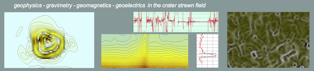
Geoelectric field campaign. Electric imaging (resistivity and induced Polarization, IP) over the active depression near the Mörn farmhouse. Instrument Lippmann 4point light high power für spectral IP measurements.

Electrical imaging profile over the active depression at the Mörn farmhouse. Resistivity and Induced Polarization (IP) pseudosections. Note the clear signature of the intrusions from below seen in the IP section. In many cases IP proves to supply a much better resolution of underground structures compared with resistivity.